
CheckCountryProjection
A new solution to detect and define the coordinate system of gis data based on geographic names automatically was developed by The Austrian Service for Torrent and Avalanche Control (The Austrian Federal Ministry of Agriculture, Forestry, Environment and Water Management). GIS-Users with almost no knowledge of coordinate systems and projections have often problems to integrate gis data in their projects, because the datasets have a wrong, or no projection definition. Since the solution works in the Austrian Service for Torrent and Avalanche Control, the support time for such problems decreased rapidly. The solution is based on the combination of geographic names (for instance a district) and geometries of the location saved in different coordinate systems. With this combination is it possible to detect and define the coordinate system without specialized knowledge. You can find detailed information published in AGIT ‒ Journal für Angewandte Geoinformatik (2016) HERE.
On the base of this development, there are such solutions for other countries possible. You
find a free sample application in German for Austria and in Spanish for Spain in the GIS Application Store.
The map of Australia below explains this approach for English speaking gis users:
If you have a shapefile with an unknown coordinate system in Tasmania, you can intersect the bounding box of the shapefile with polygons of the island in different coordinate systems and the polygon with the correct EPSG will intersect the bounding box.
For larger administrative unites like Western Australia, you have to select additionally a large scale administrative unit like the polygon of Perth City projected in different cooridnate systems, to get the correct EPSG-Code for your shapefile located in Perth City:
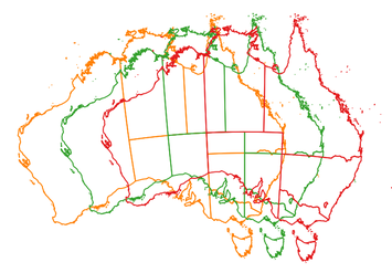
Map projections: GDA94 / MGA zona 55 (EPSG: 28355), GDA94 / MGA zona 54 (EPSG: 28354) and GDA94 / MGA zona 53 (EPSG: 28353). Incorporates or developed using Administrative Boundaries ©PSMA Australia Limited licensed by the Commonwealth of Australia under Creative Commons Attribution 4.0 International licence (CC BY 4.0).
Try this test webapplication for Australia in English for unknown coordinates:
https://maegger.github.io/map_australia.html
Using Web Feature Services (WFS), like these of Bundesamt für Kartographie und Geodäsie, similar webservices comparable to www.projfinder.com would be possible for administrative units. You could project extents of administrative units in geographic coordinates in different projections and if your unknown data intersects one or more of this projected extents, you get a small list of possible .prj for your shapefile.